Position determination
Once in flight, a principal task of the FMS is to determine the aircraft's position and the accuracy of that position.

Once in flight, a principal task of the FMS is to determine the aircraft's position and the accuracy of that position.
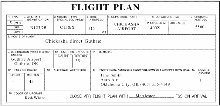
The flight plan is generally determined on the ground, before departure either by the pilot for smaller aircraft or a professional dispatcher for airliners.
Flight Management System
A flight management system (FMS) is a fundamental component of a modern airliner's avionics.
An FMS is a specialized computer system that
automates a wide variety of in-flight tasks,
reducing the workload on the flight crew to the point that
این سیستم برای بدست آوردن فاصله افقی هواپیما تا باند مورد استفاده قرار می گیرد.
Wide Area Augmentation System
سیستم ناوبری توسعه یافته توسط FAA جهت بکارگیری GPS با هدف افزایش دقت و accuracy, integrity, and availability
سیستم WAAS تمایل دارد تا تمامی فاز های پروازی را به GPS واگذار نماید.
A non-directional (radio) beacon (NDB)
is a radio transmitter at a known location, used as an aviation or marine navigational aid.
As the name implies, the signal transmitted does not include inherent directional information, in contrast to other navigational aids such as low frequency radio range, VHF omnidirectional range (VOR) and TACAN.
The U.S. Federal Aviation Administration's (FAA) Instrument Flying Handbook defines IFR as: "Rules and regulations established by the FAA to govern flight under conditions in which flight by outside visual reference is not safe.

tactical air navigation system
TACAN in general can be described as the military version of the VOR/DME system.
هنگامی که یک هواپیما دچا رسانحه می شود ، و سیستم ELT آن شروع به ارسال سیگنال می نماید ، پس از دریافت سگنال آن توسط ماهواره ها ، یکی از روشهایی که توسط آن مختصات محل حادثه بدست می آید trilateration است:
The Global Positioning System (GPS) is a network of about 30 satellites orbiting the Earth at an altitude of 20,000 km. ... Once it has information on how far away at least three satellites are, your GPS receiver can pinpoint your location using a process called trilateration.
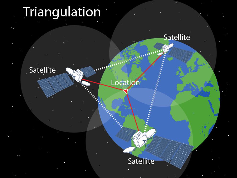
روش دیگر در یافتن محل حادثه doppler triangulation می باشد که در پستی مجزا تشریح خواهد شد.